
 October 15th, 2006
The other day I was talking to a friend about taking a road trip and we settled on something he had already picked out, a trip to Breukelen. Coincidentally, it is the same direction I went last week, only this time he picked out a different route. There were three of us, and we took off from the Uithof heading north to De Bilt. On the way we passed by the weather station in De Bilt - they had said it would be 15 degrees and sunny, it was neither. After De Bilt we headed westwards toward Groenekan. The road around these parts was very nice, fairly prosperous houses (by Dutch standards - the Dutch don't like to flout prosperity), nice gardens, quiet neighborhoods. Much of the road that came next was outside any town, so we got to see our share of the countryside, which on a chilly Sunday morning wasn't exceedingly interesting. Then we turned back into the city and arrived at city limits on the north side - Overvecht. Heading south we soon found the destination of the pursuit - river Vecht. The tour guide among us gave every assurance that staying with the river we would be right on track, which turned out to be right on all counts. :D
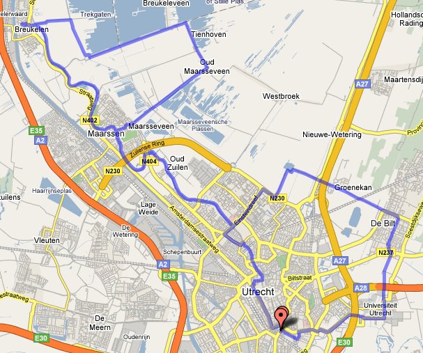
Just then I realized we had entered the riverboat-red-light-district (that I mentioned last time). As it turns out, there are about 20 or so boats, then it ends abruptly. From there on, there's a little road by the river that makes for a perfect little trip. On either side there are lots of houses, boats, gardens, the architecture takes several turns in changing from one style to the next, it's a very rich area in terms of the view. Lots of houses have boats, you'll see trees leaning over the water, old wind mills, old buildings with lots of ornaments, even an old castle that now houses a university. You'll also see a bunch of people fishing by the river. On the way to Maarssen there's a village called Oud Zuilen, which has a little castle to see. Today entrance was free, but there were so many people in there that basically we couldn't take the tour. Instead, we walked around the gardens and gazed upon the ivy covered walls of the monumental building.
Maarssen is easily the nicest part of this trip, the road by the river continues up to and through the town. Unlike the landscape up to this point, once you enter the town the buildings become much more urban in style. There is nothing sensational about Maarssen, but it's an incredibly cozy place to be. There was quite a lot of traffic on the water this time of day, people just taking a cruise around the river to enjoy themselves. There is something to be said for this river landscape, it is impressive how every detail of people's properties is cultivated carefully. There is no uncut grass, no building where the paint is coming off, no fence corroding, no trash, no mess, everything is clean and organized. And especially by the river, they have taken this to another level, and it continues past Maarssen.
The trip kind of feels like orientation that we did back in junior high. The idea is that you're out in the woods, and you have a certain route to cover. But there are no signs, so you have a map and a compass and you're on your own. If you go the wrong way, by the time you realize it, you would have lost time and you have to make up this distance. On the route, there are posts. At every post there is something you have to do, like take a number from that post to show that you've been there. In school, we did this out in the streets, which is not precisely the way it's supposed to be.. :D This trip reminded me of orientation, how we went from village to village.
But the target was always Breukelen, and that was coming up next. Breukelen is a small town, very sleepy on a Sunday afternoon. We rode into the center, onto the square, where there's a church and a series of stores and restaurants. For some reason, there was a biker convention right there today, tons of motorbikes parked in the square, with funny people dressed in black leather loitering around the area. We grabbed some lunch in one of the cafe's, right next to the bikers in fact.
Then it was time to head out, and we decided to check out the rectangular shaped lakes that lie pretty near Breukelen eastwards. It's a strange thing, normally lakes are shaped by the landscape of hills around them, but here they are carved out by man to all kinds of shapes, usually rectangles. The lake and accompanying canals east of Breukelen have this odd property, the canals are cut inland while the lake is found beyond them. In these canals there are quite a few boats. Halfway to Tienhoven, we turned off the bikepad (which was sunken next to the road, so we couldn't see much of the lake) onto a beach. The beach was very small, literally 2-3m of sand, then water, then a fence cutting off the water at some 70cm height. I imagine the water gets quite deep after that, so probably for safety they put up the fence. Out on the lake, it wasn't too windy, but quite a lot of boats out there anyway. Also a couple of wind surfers who seemed quite apt. I imagine that in beach weather, this place is pretty packed.
As we got back on the road, we were just a couple of kilometers from Tienhoven, so we decided to check it out. This ride isn't very interesting, for the most part there is a sunken bikepad along a road that blocks the view of the lake, so all you see is huge fields with farm animals wandering around on your right. Tienhoven isn't terribly interesting either, a little satellite town of Maarssen, for those fed up with big city life, it's basically one street of houses on either side, and that's all there is to it. From the road, there are canals everywhere, but no view of the lake anymore. Following the road south, you land in Oud Maarsseveen, which a settlement that's even smaller. From here on, we took a right to head back into Maarsseen. This ride is exactly the same as the first one, except there is no lake to see. About halfway through, there is a settlement on the left (which isn't even marked down on Google Maps), which has a hill, yes, a hill, on display. Incredibly unusual in these lands, the hill seems to be somewhat of a tourist attraction, I know I saw some benches and garbage cans around it.
As we approached Maarssen, we didn't have any clear cut plans on which way to go back, so we let the signs guide us onto the same road by the Vecht that we came from. By now, the sun was just peeking through the clouds and it was getting warmer. The route by the river wasn't quite the same, we weren't seeing it for the first time anymore. But it was nicer with the houses all lit up by the sun. Finally, we got back to the red light area and from there on it was just heading into the center, where we split up to and headed home. All in all, a very scenic and nice trip. The pace was low and casual, so no rush and no sweat. I was quite pleased with the weather, a hot day would have started to bug me after the first hour, this way I was neither cold nor sweating. A little tip for a trip like this: bring gloves.
When I marked out the route on Gmaps Pedometer, it showed me 52km. That's pretty far, I can't remember the last time I spent 5 hours on a bike and traveled that far. When I go by myself, I usually get enough after an hour or two, I suppose it was the company that made it more fun to cover more ground. You can inspect every nook and cranny of our trip on the site, in full zoom in/zoom out detail.
That sounds cool. We went on holiday in the region once, I remember we visited Maarssen but I don't really remember the town itself...
BTW did you know Breukelen used to be relatively important during the golden age? Guess where the name Brooklyn in NYC comes from.
Yeah, I wikipedia'd that little nugget the other day.